In this article, we have worked to give more comprehensive information regarding Tsum Valley Trek. Particularly, you will get detailed information about Tsum Valley Trek including route, map, and altitude sickness. We have also provided guidance on weather conditions, best time, trekking gears, and altitude sickness. In addition, you can also find the information from the responsible trekking operator which we recommend.
If you want it for future reference, you can bookmark this page, and you also can email this link to your friend who is planning to make this trip. Also, don’t forget to share with your friends and family via social media.
Note: If you don’t find your answer below, leave a comment. We will respond within 24 hours.
Tsum Valley – Brief Overview
An isolated place from modern development, Tsum Valley is the ultimate destination of this trek, which lies in Gorkha District, Nepal. This remote land is so unexplored, the inhabitants of this valley still practice a polyandry system which makes them culturally and traditionally distinct. Tsumbas is the major ethnic group of this valley who have claimed to have encountered Yeti – The Imaginary Giant Human. Tsum Valley occupies around 1663 square meters from the lowest place Lhokpa (1905m) to the highest Ngula Dhojyang Pass (5093m) bordering Tibet. The valley is surrounded by Sringi Himal to the north, Ganesh Himal to the south, and Himalchuli to the west.
Tibetan Buddhist culture is cunning in Tsum valley since the indigenous “Tsumbas” are of Tibetan origin. The countryside is overshadowed by superior Mt Ganesh and the greenery scene of the forest is really stunning aspects of Tsum Valley.
Tsum Valley Trek Itinerary
| Day | Day to Day Itinerary | Altitude | Walking Time |
|---|---|---|---|
| 1 | Kathmandu – Aarughat 7 hours bus/jeep drive; 2 hours more by jeep to Sotikhola | 890m | 9 hours drive |
| 2 | Sotikhola to Machhakhola | 930m | 6 hours |
| 3 | Machhakhola – Dobhan | 1070m | 5 hours |
| 4 | Dobhan – Philim | 1670m | 6 hours |
| 5 | Philim – Chumling | 2363m | 6 hours |
| 6 | Chumling – Chokhangparo | 3010m | 6 hours |
| 7 | Chokhangparo to Nile | 3361m | 6 hours |
| 8 | Nile – Mu Gompa | 3700m | 4 hours |
| 9 | Exploration Day | ||
| 10 | Mu Gompa – Nile – Rachen Gompa | 3240m | 5 hours |
| 11 | Rachen Gompa – Dumje | 2460m | 6 hours |
| 12 | Dumje – Philim | 1670m | 7 hours |
| 13 | Philim – Tatopani | 975m | 6 hours |
| 14 | Tatopani – Sotikhola | 890m | 6 hours |
| 15 | Sotikhola – Aarughat – Kathmandu | 570m | 9 hours drive |
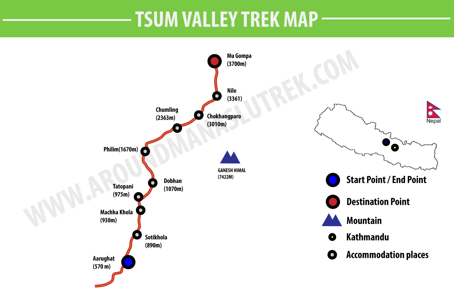
Route Map

The map above illustrates the particular route map of Tsum Valley Trek including accommodation places and their altitudes.
As shown in above figure, the trail begins and ends in Aarughat which is situated 570 above from the sea level, while the ultimate destination of this trek is to reach in Mu Gompa – Small Tibetan culture village in Manaslu.
Note: There are many places and attractions to visit in the trek. But this map does not show all those things. We have only included some key points.
Best Time to do the Tsum Valley Trek
Mainly, there are 2 best seasons to do trek in Tsum Valley – Spring (March to May) and Autumn (September to November). But this trek is opened for always and can be done any time. Although it can be completed all the year, we highly recommend you to choose April or October. Because weather becomes neither cold nor hot in these months.
Acclimatization and Altitude Sickness
Altitude sickness risk obviously comes to Tsum Valley Trek as it is a high altitude trek. The highest point on this trek, where you reach, is Mu Gompa is over 3700 m high altitude. Nevertheless, it is relatively easier than Manaslu Circuit Trek.
It is hard to predict how altitude effects trekkers. However, fitness is most important to this trek.
It will be fruitful if you keep at least one acclimatization day either in Chokhangparo or in Nile. However, it is not usually necessary if your health condition is fit.
Training and Preparation
Tsum Valley Trek is a moderate trek. So you don’t need to be super fit like of Marathon runner. However, it would be better if you maintain your health and make your shape good before coming to do this trek.
